Fishermen can find out valuable information about the
temperature of the seas.
Fishermen can find out valuable information about the
temperature of the seas.
Satellites monitor the amount of snow, ice flow in the Arctic and Antarctic, and the depth of the ocean.
Infrared sensors on satellites examine crop conditions, areas of
deforestation and regions of drought.
Some satellites have a water vapour sensor th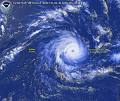 at can measure how much water vapour is in the atmosphere.
Satellites can detect volcanic eruptions and monitor the motion of ash clouds.
Satellites monitor freezing air movement allowing weather forecasters to warn growers of
coming low temperature spells.
Satellites receive environmental information from remote data collection
platforms on the surface of the Earth. These include transmitters in floating 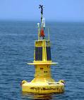 buoys, gauges of river levels and conditions, automatic
weather stations, stations that measure earthquake and tidal wave conditions,
and ships. This information, sent to the satellite from the ground, is then
relayed from the satellite to a central receiving station back on Earth.
buoys, gauges of river levels and conditions, automatic
weather stations, stations that measure earthquake and tidal wave conditions,
and ships. This information, sent to the satellite from the ground, is then
relayed from the satellite to a central receiving station back on Earth.


 Weather Satellites


 Weather satellite technology and communications satellite
technology allows you to find out the weather anywhere in the world any time of the
day. Television stations and websites carry weather information all day long.
Meteorologists use weather satellites images for many purposes:
Weather satellite technology and communications satellite
technology allows you to find out the weather anywhere in the world any time of the
day. Television stations and websites carry weather information all day long.
Meteorologists use weather satellites images for many purposes: